 Micronesia Sun Bright News from the Deep Pacific
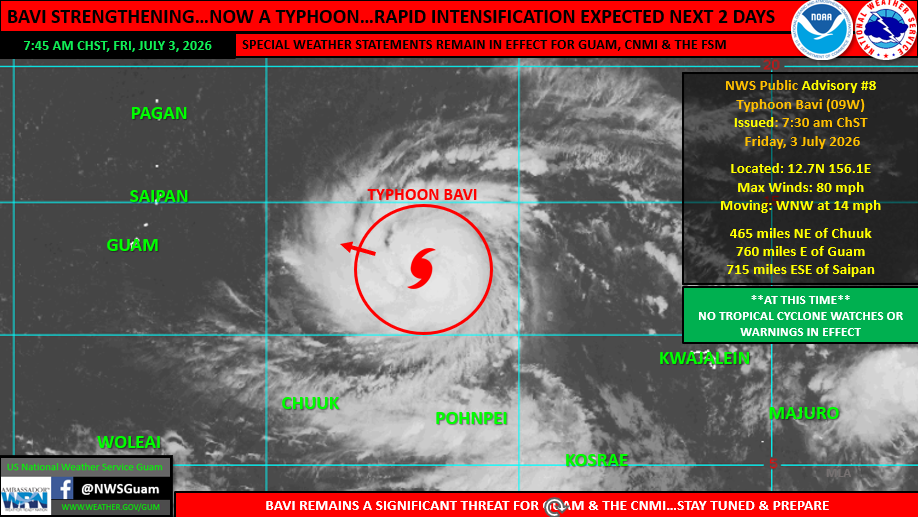
Photo Sources: U.S. National Weather Services Guam
By Christopher Cottrell
Friday, July 3, 2026, Federated States of Micronesia__Typhoon Bavi is growing intensity today and the next two on a trajectory threatening Guam and Commonwealth of Northern Marianas Islands, according to the Joint Typhoon Warning Center (JTWC) as of this morning 7:00 ChST, with U.S. Coast Guard Forces Micronesia urging emergency prepartions.
At present, Bavi is roughly 760 miles east of Guam, and 715 miles east-southeast of Saipan, moving west-northwest at 14 mph with Category-1 sustained winds of 80 mph.
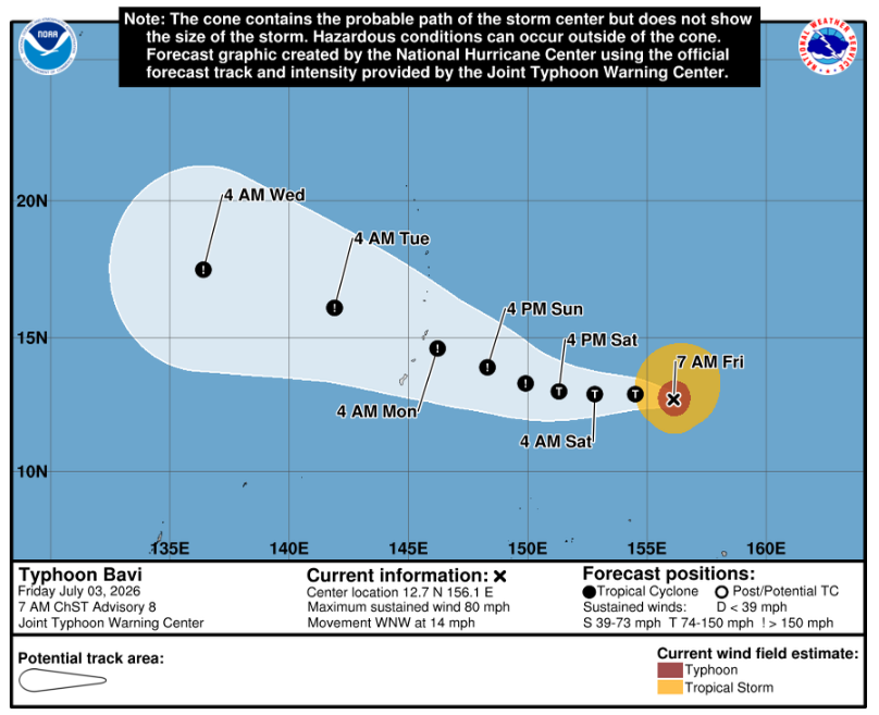
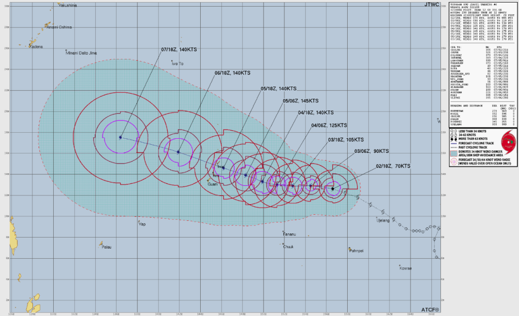
JTWC stated, “As currently forecast, this latest track still forecasts a super typhoon to be passing through the Marianas, still near, or just south of Tinian, mid to late Monday morning. Keep in mind, this is a forecast, not a guarantee…and with 2-3 days ahead, changes can, and will still occur. The overall track could still shift farther south…and closer to Guam, or farther north. Shifts in timing and intensity may also occur in the coming days as Bavi makes its approach to the region. This remains a significant threat for all of the Mariana Islands.”
It continues, “Current forecast tracks continue to indicate a grim outlook for the Marianas. All residents across Guam and the CNMI should plan for and anticipate at least tropical storm conditions. However, island(s) closest to the passage, or those potentially with a direct hit, would most likely see much stronger conditions. This is where the uncertainty remains: will the current track of Bavi shift farther to the south, or to the north. These shifts remain likely in the coming days as Bavi nears. Take steps to prepare now for the protection of life and property, and stay tuned.”
The “Special Weather Statement” for FSM’s states of Chuuk, Pohnpei and Kosrae announced on July 1, 2026 is still in effect, “for Micronesia, detailing potential impacts associated with Typhoon Bavi as it passes north of the FSM. Folks across the FSM: keep alert to weather forecasts and conditions. Although this system will pass to the north, surging west winds, showers, thunderstorms and the potential for locally heavy rainfall should be anticipated in the coming days.”
U.S. Coast Guard Forces Micronesia announced they are already taking action, “Our crews are already at work: finishing securing the base, hauling out and trailering station small boats, and preparing cutters to get underway ahead of the storm. Cutters depart to ride out the weather safely and return to respond once it’s safe — but that means on-water response is reduced before, during, and right after Bavi.”
They are urging the public to act now, advising:
- Stay out of the water. Building surf and dangerous rip currents are expected along east-facing reefs.
- Secure your gear. Kayaks, paddleboards, jet skis, and small boats that break loose become hazards — and false distress calls.
- Know how to call for help. VHF-FM Channel 16 and 911 — not social media. We don’t monitor Facebook or Instagram for distress. The SOS function on cellular phones is not reliable in this region.
- We do still have VHF outages from Sinlaku, meaning VHF in some areas is limited and may require relay from other operators. Have multiple means of communication, including EPIRBs and PLBs, cellular phones, and satellite phones.
- We do NOT recommend being out on the water going forward until well after the storm passes. If you have reason to be on the water, ensure someone knows where you are going and when you will be back, so they can alert responders if you become overdue!
Micronesia Sun continues to monitor this situation closely.
For more information at National Weather Station Guam: weather.gov/gum